1

World Wetlands Day, 2024

World Wetlands Day is celebrated every year on 2 February.

  • This day marks the date of the adoption of the Convention on Wetlands on 2 February 1971, in the
  • Iranian city of Ramsar on the shores of the Caspian Sea.
  • In 2024, India has increased its tally of Ramsar sites (Wetlands of International Importance) to 80 from existing 75 by designating 5 more wetlands as Ramsar sites.


Ratle Hydro Electric Project

The government recently announced diversion of Chenab river water through diversion tunnels to expedite the 850-MW Ratle Hydro Electric Project in Jammu & Kashmir.

About Ratle Hydro Electric Project:

  • It is an 850 MW run-of-river hydroelectric power project being built on the Chenab River in the Kishtwar District of Jammu and Kashmir.
  • The project is being developed by Ratle Hydroelectric Power Corporation (RHPCL), which was formed as a joint venture (JV) between Jammu & Kashmir State Power Development Corporation (JKSPDC) and India’s state-owned National Hydroelectric Power Corporation (NHPC).
  • The project comprises a 133-metre-tall and 194.8-meter-long concrete gravity dam, a diversion dam, and an underground powerhouse on the right bank of the river.

Key Facts about Chenab River:

  • It is a major river of India and Pakistan.
  • Origin: It is formed by the confluence of two streamsChandra and Bhaga, at Tandi in the upper Himalayas in the Lahaul and Spiti Districts of Himachal Pradesh.
  • In its upper reaches, it is also known as the Chandrabhaga.
  • It is a tributary of the Indus River.
  • Course:
    • It flows west through Jammu and Kashmir union territory, between the steep cliffs of the Siwalik Range (south) and the Lesser Himalayas (north).
    • Turning southwest, it continues into Pakistan, descending from the uplands into the broad alluvial lowlands of Punjab province. 
    • After receiving the Jhelum River near Trimmu, the Chenab empties into the Sutlej River, a tributary of the Indus River.
  • Its total length is about 605 miles (974 km), and it feeds several irrigation canals. 
  • Tributaries: The tributaries of the Chenab River include Miyar Nalla, Sohal, Thirot, Bhut Nalla, Marusudar, and Lidrari.


Soda Lake

Scientists have discovered that a shallow “soda lake” in western Canada could be a good match for Darwin’s “warm little ponds” where life got started on the primordial Earth.

About Soda Lake:

  • It is a lake with a pH value usually between 9 and 11.
  • High carbonate concentration, especially sodium carbonate, is responsible for the alkalinity of the water.
  • It may also contain a high concentration of sodium chloride and other salts making it saline or hypersaline Lake.
  • These are highly productive ecosystems compared to the freshwater lakes.
  • These are the most productive aquatic environments on Earth because of the availability of dissolved carbon dioxide.
  • They occur naturally in both arid and semi-arid areas.
  • Geology and Genesis
    • A topography that limits the outflow of water from the lake is needed.
    • An endorheic basin is formed when the water is confined without the outflow.
    • The pH of the water in the depression rises through the evaporation of the lake which requires a suitable climate like the desert climate to balance between the inflow and evaporation.
    • The rate at which carbonate salt dissolves in the lake water depends on the ecology of the surrounding area.
    • The relative absence of magnesium and calcium is critical in the formation of the soda lake since magnesium or calcium is likely to dissolve quickly and displace the carbonate ion thus neutralising the pH of the lake water.
  • Biodiversity
    • These are dominated by prokaryotes like bacteria and archaea, especially in lakes with higher levels of alkalinity.
    • Multicellular organisms such as brine shrimp and fish are found in plenty if not most of the soda lakes.
  • Examples of Soda Lakes
    • Africa and Asia have the highest number of soda lakes since the two continents have vast desert conditions which are perfect for the formation of soda lakes.
    • Most of the soda lakes in Africa are located in Eastern Africa, especially in Kenya, Tanzania, and Ethiopia.
    • Lake Natron in Tanzania is one of the most outstanding soda lakes in Africa
    • India and China have the highest number of soda lakes in Asia.
    • Some of the soda lakes in Asia include Lake Van, Tso Kar Salt Lake, Pangong Salt Lake, and Lake Zabuye.


Big Ring

Recently, scientists have discovered massive superstructures in space and named it as Big Ring.

  • Big Ring – They are ultra-large superstructure in the sky, about 9.2 billion light-years away from Earth.
  • It isn’t actually even a ring, it’s coiled sort of like a slinky.
  • Formation – It is made up of galaxies and galaxy clusters.
  • Diameter – About 1.3 billion light years.
  • Circumference – About 4 billion light-years.
    • It would take 15 full Moon to cover it despite being millions of times farther away than the natural satellite.

Giant Arc is the previously discovered super structure which is even more massive, with a diameter of 3.3 billion light-years. Both the Big Ring and the Giant Arc are cosmic neighbours and are only about 12 degrees apart from the time.

  • Challenges – Both the super structures defy cosmological theory.
  • Unlike Baryonic Acoustic Oscillations (BAOs), it is too large and is not spherical and another theory is that it could be caused by cosmic strings.
  • Thus, their ultra-large sizes, distinctive shapes, and cosmological proximity needs to be studied further.

Scientific concepts related to Big Ring

  • Cosmological theory – All structures in the universe can be traced back to the cosmic microwave background (CMB) radiation, the so-called “fireball of the Big Bang” that scientists observe filling the universe.
  • Baryonic Acoustic Oscillations (BAOs) – They are acoustic waves from the early universe, and statistically, they should appear as spherical shells in the arrangement of galaxies.
  • Cosmic strings – They are hypothetical 1D topological defects believed to have formed from the remnants of the cosmic fabric, left over from cosmic symmetry breaking shortly after the Big Bang.
  • They are extremely thin and possess an immense amount of energy.
  • Quasars – They are extremely luminous interiors of active galaxies which are powered by supermassive black holes.


Lake Retba

The Lake Retba’s waters are virtually devoid of life and are on the verge of disappearing due to pollution and mining.

About Lake Retba:

  • It is also known as Lac Rose (the Pink Lake).
  • Location: It is located north of the Cap Vert peninsula of Senegal, northeast of Dakar (Senegal).
  • The lake is isolated from the sea by sand dunes.
  • Its fresh water comes from the seasonal water table in the dunes, which are higher than the lake. Thus, the sea provides most of the lake’s water and all of its salt.
  • The Pink Lake is one of the main tourist destinations in the Dakar region, primarily because of the pink colour of its waters.
  • Why is it pink?
    • The pink coloration is due to the proliferation of halophilic green algae (living in a salty environment), Dunaliella salina, which contain red pigments.
    • The algae is associated with halophilic bacteria of the genus Halobacterium.
    • This microscopic alga’s resistance to salt comes from its high concentration of carotenoid pigments, which protect it from light, and its high glycerol content.
    • In fact, Dunaliella salina contains at least four antioxidant pigments (beta-carotene, astaxanthin, lutein and zeaxanthin), which are rich in vitamins and trace elements.
    • When salinity is high, algae with red pigments thrive, and when salinity is low, they give way to other algae rich in green pigments.


Copper Reserves

India to send industry delegation for copper mining opportunities in Zambia.

  • The Mines Ministry has proposed sending an Indian industry delegation to copper-rich Zambia to discuss potential copper exploration and mining projects in the southern African country.

China Nonferrous Mining Corporation (CNMC) is among the largest producers of copper in Zambia.

Copper

  • Copper is a good conductor of electricity and is ductile.
  • Alloys – Alloyed with iron and nickel to make stainless steel.
    • Alloyed with nickel to make ‘morel metal’.
    • Alloyed with aluminium to make ‘duralumin’.
    • Alloyed with zinc it is known as ‘brass’ and with tin as ‘bronze’.
  • Copper is widely used in sectors like construction, consumer durables, transportation, and industrial manufacturing.
  • It is also used in clean energy technologies including solar panels, EVs, and energy efficient motors.
  • Reserves in India – 46 million tones; Rajasthan (50%); Madhya Pradesh (24%); Jharkhand (19%); 7% in AP, Gujarat, Haryana, Karnataka etc.

As per International Copper Association India, domestic copper demand grew by 16% in FY2022-2023, while demand for copper in clean energy technologies grew by 32%.

Copper Reserves in India

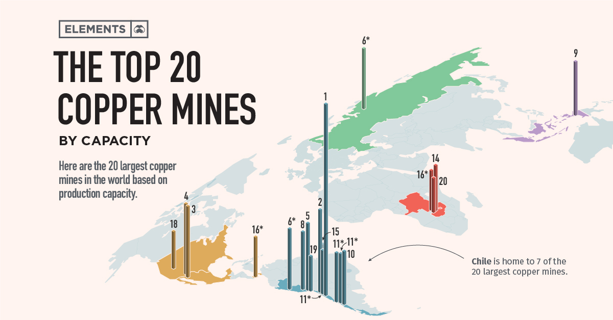
  • Reserves across globe – Chile has the world’s largest copper reserves of any country by far, with 190 million metric tons as of 2022.
  • It is also the world’s largest copper producer, having produced some 5.2 million metric tons of copper from mines in 2022.

Copper Reserves of world 2024

Zambia

  • It got its name from the Zambezi River.
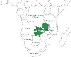
  • The country is located in southern Africa.
  • Zambia is a landlocked country of rugged terrain and diverse wildlife, with many parks and safari areas.
  • On its border with Zimbabwe is the famed Victoria Falls, plunging into the narrow Batoka Gorge.

Zambia has about 6 per cent of the world’s copper reserves and was the eighth-largest producer of copper in 2022.

Zambia map 2024


Wular Lake

The Wular Lake has got around four to five lakh migratory birds so far this winter, including seven new species.

About Wular Lake:

  • It is the largest freshwater lake in India.
  • It is located in the Bandipora district of Jammu and Kashmir.
  • It lies at the north end of the Valley of Kashmir, 20 miles (32 km) north-northwest of Srinagar. 
  • It is spread over a total area of 200 square km covering almost 24 km in length and 10 km in breadth. 
  • The lake basin was formed as a result of tectonic activity and is fed by the Jhelum River.
  • The lake lies at an altitude of 1,580 m.
  • It is also said to be a remnant of Satisar Lake, that existed in ancient times. 
  • This lake also has a small island in its centre called the ‘Zaina Lank’. This island was constructed by King Zainul-Abi-Din.
  • In 1990, it was designated as a Ramsar Site.

Key Facts about Jhelum River:

  • It is a river that flows in India and Pakistan.
  • It is a tributary of the Indus River.
  • It is the main waterway of the Kashmir valley.
  • Course:
    • Origin: It originates at the Verinag Spring at Anantnag, at the foot of the Pir Panjal range in the Kashmir Valley.
    • It then flows via Srinagar and Wular Lake prior to entering Pakistan.
    • The river makes a deep, narrow gorge on its way to Pakistan.
    • It joins the Chenab River near Trimmu, Pakistan.
  • Length: It has a total length of about 725 km (450 mi).
  • Major Tributaries: Kishanganga (Neelum) River, Kunhar River, Sandran River, Bringi River, Arapath River, Watlara River, Lidder River, and Veshaw River.


Willingdon Island

Recently, the Cochin Port Joint Trade Union Forum has urged the Prime Minister of India to take effective steps to revive the lost glory of Willingdon Island.

About Willingdon Island:

  • It is among the most beautiful locations in the Kochi area.
  • This is a man-made island, named after Lord Willingdon who was a British Viceroy of India.
  • It is among the biggest of its kind in India.
  • It is a major commercial centre and has some of the best hotels in the city.
  • It is also home to the Kochi Naval Base of the Indian Navy, the Central Institute of Fisheries Technology and the Port of Kochi.
  • It handles millions of tonnes of freight every year.
  • The island is connected to the mainland by the Venduruthy Bridge.

Who was Lord Willingdon (1931 – 1936)?

  • He was the 22nd Viceroy and Governor-General of India.
  • Major events during his tenure
    • Introduction of the Government of India Act, 1935.
    • The Second Round Table Conference, held in 1931, saw the participation of Gandhi as a representative of the Congress. 
    • British Prime Minister Ramsay MacDonald introduced the Communal Award in 1932.
    • The Poona Pact of 1932was reached between Gandhi and Ambedkar to address provisions related to fair representation of backward classes.
    • The Third Round Table Conference, held in 1932, failed as neither Gandhi nor Congress attended.


Indian Tectonic Plate

Researchers recently unveiled new seismic data indicating that the Indian tectonic plate is splitting in two beneath the Tibetan plateau.

About Indian Tectonic Plate:

  • It is a minor tectonic plate.
  • It is bound by four major tectonic plates. North of the Indian plate is the Eurasian plate; to the south east is the Australian plate; to the south-west is the African plate; and to the west is the Arabian plate. 
    • As the Indian plate moves northward relative to the Eurasian plate and collides with it, a convergent boundary is created.
    • On the opposite side, the Indo-African boundary is divergent.
    • The western Indo-Arabian boundary is lateral relative to each other, giving rise to a transform boundary.
    • It was previously thought that the Indian and Australian plates formed one single plate as there is no clear type of boundary but recent seismologic evidence suggests that the two plates will have a transform boundary, as the drift velocities of these two plates are different even if the general direction of motion of the two plates is similar.
  • The collision of the Indian plate with the Eurasian plate about 50 million years ago resulted in the erection of the Himalayan Mountains.
  • As the Indian plate is still active today and drifts at a velocity of about 5 cm per year, earthquakes occur in the northern part of the plate.


Panama Canal

Scientists recently stumbled upon a lost forest in the Panama Canal, dating back around 22 million years.

About Panama Canal:

  • It is an artificial waterwaythat connects the Atlantic Ocean with the Pacific Ocean.
  • The canal cuts across the Isthmus of Panama and is a conduit for maritime trade.
  • It was cut through one of the narrowest saddles of the isthmus that joins North and South America.
  • It is one of the two most strategic artificial waterways in the world, the other being the Suez Canal. 
  • It is approximately 80 kilometres long.
  • It consists of a series of locks that raise and lower the water level to facilitate the passage of ships through the continental divide.
  • History:
    • France began work on the canal in 1881, but financial troubles and diseases made the initiative fail.
    • The United States took over the project on May 4, 1904, and opened the canal on August 15, 1914, and then managed the waterway until 1999.
    • On December 31, 1999, Panama took over full operation, administration, and maintenance of the Canal, in compliance with the Torrijos-Carter Treaties negotiated with the United States in 1977.


Cauvery basin

The National Green Tribunal (NGT) has served notices to Karnataka, Tamil Nadu and Kerala governments, based on a report by the Indian Institute of Science (IISc) that has highlighted the massive reduction of green cover in the Cauvery basin over the past five decades.

About Cauvery basin:

  • It extends over states of Tamil Nadu, Karnataka, Kerala and Union Territory of Puducherry.
  • It is bounded by the Western Ghats on the west, by the Eastern Ghats on the east and the south, and by the ridges separating it from Krishna basin and Pennar basin on the north.
  • The Cauvery River is one of the major rivers of the peninsula.
  • Origin: It rises at an elevation of 1,341 m at Talakaveri on the Brahmagiri range near Cherangala village of Kodagu district of Karnataka. 
  • The river drains into the Bay of Bengal at Poompuhar in the Mayiladuthurai district of Tamil Nadu.
  • Major left bank tributaries: Harangi, the Hemavati, the Shimsha and the Arkavati.
  • Major right bank tributaries: Lakshmantirtha, the Kabbani, the Suvarnavati, the Bhavani, the Noyil and the Amaravati.
  • The basin can be divided into three parts – the Western Ghats, the Plateau of Mysore and the Delta.
  • The delta area is the most fertile tract in the basin.
  • The principal soil types found in the basin are black soils, red soils, laterites, alluvial soils, forest soils and mixed soils. Red soils occupy large areas in the basin. Alluvial soils are found in the delta areas.
  • National Parks in this basin: Bandipur National Park, Nagarhole National Park and Bannerghatta National Park.


Mahanadi River Basin

The state-owned Oil and Natural Gas Corporation (ONGC) recently discovered two significant natural gas reserves in the Mahanadi basin block in the Bay of Bengal.

About Mahanadi River Basin:

  • It is the 8th largest river basin in the country, with a total catchment area of 139681.51 sq. km, which is nearly 4.28% of the total geographical area of the country.
  • The catchment area of the basin extends over major parts of Chhattisgarh and Odisha and comparatively smaller portions of Jharkhand, Maharashtra, and Madhya Pradesh.
  • The basin has a maximum length and width of 587 km and 400 km, respectively. 
  • It is bounded by the Central India hills on the north, by the Eastern Ghats on the south and east, and by the Maikala range on the west. 
  • Physiographically, the basin can be divided into four regions, namely, the northern plateau, the Eastern Ghats, the coastal plain, and the erosional plains of central table land. 
    • The first two are hilly regions. 
    • The coastal plain is the delta area, which is highly fertile.
    • The central tableland is the central interior region of the basin, traversed by the river and its tributaries.
  • The basin receives about 90% of its rainfall during the monsoon season.
  • The major part of the basin is covered with agricultural land, accounting for 54.27% of the total area, and 4.45% of the basin is covered by water bodies. 
  • The main soil types found in the basin are red and yellow soils. 

Key Facts about Mahanadi River:

  • It is one of the major east-flowing peninsular rivers in India.
  • Origin: The river originates from the Sihawa range of hills in the Dhamtari district of Chhattisgarh state.
  • It ranks second to the Godavari River among the peninsular rivers in respect of water potential.
  • The total length of the river from origin to its outfall into Bay of Bengal is 851 km of which 357 km lies in Chhattisgarh and 494 km in Odisha.
  • Tributaries: The Seonath, the Hasdeo, the Mand, and the Ib join Mahanadi from left, whereas the Ong, the Tel, and the Jonk join it from right. 
  • Hirakud Dam: The Hirakud Dam, the world’s longest earthen dam (26km), is constructed across the Mahanadi River, about 15 km from Sambalpur in Odisha.
  • Chilika Lake: Chilika, named wetland of international importance under the Ramsar Convention, gets 61% of its inland flow from the Mahanadi River system, mainly from its distributaries, Daya and Bhargabi.


Lentil Production

India is set to become the world’s largest producer of lentil (masoor) during the 2023-24 crop year on account of higher acreage.

Lentils
  • Scientific name – Lens culinaris
  • It is a small annual legume of the pea family (Fabaceae) and its edible seed.
  • Types – Green lentils, Red & Yellow lentils, Black lentils and Brown lentils.
  • Nutrition – It has high protein and fibre content.
  • Cultivation – Throughout Europe, Asia, and North Africa but are little grown in the Western Hemisphere.
  • Benefits – It helps in nitrogen fixation in the soil.
  • Cultivation in India – Agriculture Ministry shows that 19.45 lakh hectares is under lentil till January, 2024, 6% higher from last year’s area, and 37% higher than the normal area.
  • India’s lentil production – In the 2022-23 crop year, it stood at 1.56 million tonne.
    • According to FAO, India is world’s 2nd largest lentil growers (1.26 million tonnes) in 2022 while Canada tops the chart. followed by India.

Lentil Production in India has tapered since 2017-18 when the country recorded its highest output of 1.62 million tonne. But Indian government had increased the MSP of lentils to Rs 6,425 per quintal for the Rabi Marketing Season 2024-25 from the Rs 2,950 per quintal in 2014-15.

  • Imports – It is to meet its domestic requirements, buying mainly from Australia, Canada, Russia, Singapore, and Turkey.
  • During the current year, it also imported some quantities of lentil from UAE, USA, Sri Lanka and Nepal.


Krishna Raja Sagar (KRS) Dam

The High Court of Karnataka recently banned all types of mining and quarrying activities within a 20-km radius of the historic Krishnarajasagar (KRS) dam in Mandya district.

About Krishna Raja Sagara (KRS) Dam:

  • It is a type of gravity dam located below the confluence of the river Kaveri with its tributaries, Hemavati and Lakshmana Tirthain the district of Mandya in Karnataka. 
  • History:
    • The dam was constructed during the rule of the Maharaja of Mysore, Krishnaraja Wadiyar IV, and it was named in his honour.
    • The construction of the KRS Dam began in 1911 and was completed in 1931.
    • The dam was designed by Sir M. Visvesvaraya, a famous Indian engineer (often referred to as the ‘architect of modern Mysore’ or ‘father of planning in India’).
    • The creative beautification of the whole dam complex has been the achievement of Sir Mirza Ismail, the then Dewan of the princely State of Mysore.
  • Usage:
    • The water from the dam is used for irrigation in Mysore and Mandya and is the main source of drinking water for Mysore, Mandya, and Bengaluru city. 
    • It also ensures power supply to the Shivanasamudra hydroelectric power station.
    • The water released from this dam flows into the state of Tamil Nadu and is stored in the Mettur dam in the Salem district. 
  • Features:
    • It was built using a mixture of surki mortar and limestone. 
    • It is 2,621 metres (8,600 feet) long and 40 metres (130 feet) high.
    • Its reservoir is about 130 sq. km, which was the largest in Asia at the period when it was built.
    • It was the first dam to install automated crest gates.
    • Brindavan Gardens, an ornamental garden, is attached to the dam. 
      • The garden is designed based on the Shalimar Gardens of Kashmir in the Mughal style.


Rock glaciers

A new study revealed that over 100 active permafrost structures identified in the Jhelum basin, can cause catastrophic disasters in future.

About Rock glaciers:

  • A rock glacier is a mass of rock, ice, snow, mud, and water that moves slowly down a mountain under the influence of gravity. 
  • Unlike an ice glacier, rock glaciers usually have very little ice visible at the surface
  • The rock glacier might consist of a mass of ice covered by rock debris, or it might consist of a mass of rock with interstitial ice.
  • Formation:
    • Rock glaciers typically form in mountainous regions where there is a combination of permafrost, rock debris, and ice.
    • One common scenario involves a pre-existing glacier that accumulates debris and rocks as it moves.
    • Over time, if the glacier recedes or thaws, the debris-covered ice can transform into a rock glacier.
    • These are classified as ‘active’ or ‘relict’ to indicate the status of permafrost within them, identified by the appearance of the rock surfaces. 
  • Impacts
    • It increases the risk of glacial lake outburst floods (GLOFs).
    • It may also make landslides more frequent with the land on the melting ice becoming loose.


Inland Waterways Development Council (IWDC)

Harit Nauka guidelines and the River Cruise Tourism Roadmap 2047 were launched at the recently held inaugural Inland Waterways Development Council (IWDC) in Kolkata.

  • IWDC – It is hosted by the Inland Waterways Authority of India.
  • Establishment in – 2023
  • Objectives – For comprehensive development of inland waterways and associated ecosystems with improved cargo efficiency, passenger movement, and river cruise tourism, with active participation from the States and UT’s.

Harit Nauka

  • Harit Nauka – It is the ‘Guidelines for Green Transition of Inland Vessels’.
  • Launched by – Ministry of Ports, Shipping, and Waterways.
  • Aim – To embark on a journey towards a sustainable and eco-friendly future for our inland waterways.

River Cruise Tourism Roadmap 2047

  • Launched by – Ministry of Ports, Shipping, and Waterways.
  • Roadmap – To enable capacity in an additional 26 waterways fit for river cruise tourism from an operational strength of 8 waterways.
  • To increase cruise routes with night stays from 17 to 80 and to increase river cruise terminals from 15 up to 185, registering a growth of 1233%.
  • To move the cruise tourism traffic with night stays up from 5000 to 1.20 lakh and the local cruise tourism traffic on National Waterways without night stays up from 2 lakh to 15 lakh by 2047.
  • It had identified 30+ additional potential routes for different cruise types, including long and short, recreational, and heritage segments, to attract all tourist categories.


Maldives

The Maldives government recently suspended three of its ministers after they shared offensive remarks against the Indian Prime Minister on social media.

About Maldives:

  • It is a low-lying island country in the north-central Indian Ocean
  • Its closest neighbours are India, about 600 kilometres north-east, and Sri Lanka, about 645 kilometres north-east.
  • Geography:
    • It consists of a chain of about 1,200 small coral islands and sandbanks (some 200 of which are inhabited), grouped in clusters, or atolls.
    • The atolls have sandy beaches, lagoons, and a luxuriant growth of coconut palms, together with breadfruit trees and tropical bushes.
    • The islands extend more than 510 miles (820 km) from north to south and 80 miles (130 km) from east to west.
    • None of the coral islands stand more than 1.8 metres (six feet) above sea level.
    • Barrier reefs protect the islands from the destructive effects of monsoons. 
  • Capital: Male
  • Languages
    • The official language is an Indo-European language called Dhivehi (or Maldivian).
    • Arabic, Hindi, and English are also spoken.
  • Islam is the state religion.
  • Economy: It revolves mainly around tourism.
  • Constitutional Framework: The constitution of the Maldives was adopted in 2008.
    • The head of state and government is the presidentassisted by a vice president and a cabinet.
    • The president and vice president are directly elected by universal suffrage to a maximum of two five-year terms.


National Centre for Seismology (NCS)

An earthquake of magnitude 3.9 hit Jammu and Kashmir’s Kishtwar district recently, as reported by the National Centre for Seismology.

About National Centre for Seismology (NCS):

  • NCS is the nodal agency of the Government of India for monitoring of earthquake activity and conducts seismological research in the country. 
  • It is an attached office of the Ministry of Earth Sciences (MOES).
  • The NCS monitors earthquake activity all across the country through its 24×7 round-the-clock monitoring centre for better understanding of earthquake source processes and their effect on the cause of earthquake-safe society.
  • It consists of various divisions:
    • Earthquake Monitoring and Services
    • Earthquake Hazard and Risk Assessments
    • Geophysical Observation Systems
  • It operates and maintains the NSN, or the National Seismological Network. The NSN consists of 153 seismological observatories spread across the country.
    • NSN is capable of recording earthquakes and events of magnitude (M)≥2.5 in and around Delhi, M≥3.0 for the North East (NE) regionM≥3.5 in the peninsular and extra-peninsular areas, and M≥4.0 in border regions
  • Whenever an earthquake occurs in the country, its information is immediately disseminated by NCS to a variety of user agencies, including disaster management authorities. 
    • The NCS shares this information via earthquake bulletins within five minutes of an earthquake.
  • It is also involved in the monitoring of aftershock and swarm activity, if occurred, throughout the country.
  • Another important activity implemented by the NCS is microzonation. It is a site-specific study that provides a more realistic and reliable representation of ground motion characteristics.
    • It is useful in land use and urban planning, as well as in retrofitting of existing buildings.


Geographical Indication (GI) Tag Products

Over 17 products from Odisha, Arunachal Pradesh, West Bengal, and J&K bagged the coveted Geographical Indication tag.

GI Tags

  • Geographical indications assign products to the place of its origin.
  • It conveys an assurance of quality and distinctiveness for such goods.

A total 504 items from different parts of the country have had the tag so far since 2004.

  • GI is defined under Article-23 and 24 of the Trade-Related Aspects of Intellectual Property Rights (TRIPS) Agreement of the World Trade Organization (WTO).
  • India is a member of the WTO and thus enacted the Geographical Indications of Goods (Registration & Protection) Act, 1999 that came into force from 2003.

Under Articles 1 (2) and 10 of the Paris Convention for the Protection of Industrial Property, geographical indications are covered as an element of Intellectual Property Rights.

  • GI tagged products can be both Natural or Man-made.
  • The GI Tag is valid for ten years.
  • The essential difference between GI and other intellectual properties (IP) is that, GI is a collective intellectual property right.

The first product in India to be accorded with GI tag was Darjeeling Tea in the year 2004-05.

Recent GI Tagged Products

Arunachal Pradesh

Wancho Wooden Craft
  • Wancho wooden craft items are unique as they feature tobacco pipes with head-shaped bowls and drinking mugs showing warriors carrying heads.
Adi Kekir (Ginger)
  • Adi Kekir is a variety of ginger produced in East Siang, Siang and Upper Siang districts of Arunachal Pradesh.
  • It is known for its taste and size.
Handmade Carpets
  • The handmade carpets made by Tibetan refugees, who live in various parts of the state, are known for their typical designs, motifs and textures.

So far, six products from Arunachal Pradesh have received the GI certification.

West Bengal

Tangail Saree
  • The hugely popular tangail cotton sarees have finer count and are decorated with extra warp designs using coloured yarn.
  • It is a simplification of the jamdani cotton saree but with minimal designs in the body portion.
Garad Saree
  • Garad silk sarees are characterized by a plain white or off-white body, an unornamented coloured border and a striped pallu and were earlier worn for performing pujas.
  • With the change in taste, various colours and woven patterns have been introduced.
Korial Saree
  • The korial sarees are lavish silk ones.
  • They are in either white or cream base and have the characteristic heavy gold and silver embellishments of Benarasi sarees in the border and pallu.
Kalonunia Rice
  • It is one of the most sought after rice variety in north Bengal.
  • Kalonunia is a traditional black-husked non-Basmati type scented rice of Tarai region (foothills of eastern Himalayas) of West Bengal, India. 
Sundarban Honey
  • The Sundarban honey, called Mouban, is a prime minor forest produce (MFP) in Sundarbans Biosphere Reserve.
  • The residents of Sundarbans are called Mauli.

With this, Bengal has a total of 27 GI tags to date.

Odisha

Dhenkanal Magji
  • It is a famous and unique sweet of the Dhenkanal district.
  • Its taste, flavor, and method of preparation have made it unique.
  • The buffalo milk cheese gives it a unique flavor and cardamom powder adds to its unique aroma.
Khajuri Guda
  • Khajuri Guda (date palm jaggery) is a natural sweetener produced from the sweet juice of palm called neera.
  • The jaggery is prepared by the tribal populations, including the Lanjia Saura, of Gajapati, Boudh, Angul, and Dhenkanal districts in Odisha.
Similipal Kai Chutney
  • The chutney is made with read weaver ants by the tribal people of Odisha’s Mayurbhanj district.
  • The hot chutney has a pungent and sour taste and is appetizing.
Nayagarh Kanteimundi Brinjal
  • It is a tasteful vegetable with lots of prickly thorns on it as well as the whole plant.
  • It is green in colour and round in shape containing more seeds as compared to other genotypes.
  • The vegetable crop is cultivated in the sandy soil and having unique taste, flavor.
  • This crop is grown both in the Kharif and Rabi seasons.
Dongaria Kondh Embroidery Shawl
  • The traditional knitted shawls of the hill tribe Dongaria Kondh are both unique and ancient.
  • Their culture, tradition, faith, and beliefs, as well as the biodiversity of their forests are reflected in the shawls.
  • Dharanipenu, the much adored goddess of the Dongaria, has a home in every village.
  • The art and drawings made in the Dharanipenu residence are reflected in their shawls.
Koraput Kalajeera Rice
  • Koraput Kalajeera Rice known as the ‘Prince of Rice’ is an aromatic variety originating from Koraput district of Odisha.
  • Upholding the nutritional and cooking quality, the rice looks like coriander seeds.
Lanjia Saura Paintings
  • The Lanjia Saura paintings are a style of wall mural art.
  • Those paintings also called ekons or the idital, and have a significant spiritual importance for the tribe.
  • The Lanjia Sauras are an indigent society today, and labour in preserving their culture, the iditals being an important part of it.

With this, Odisha has received 25 GI tags to date.

Other States

Gujarat

Kachchhi Kharek
  • They are a variety of dates grown in the Kutch region of Gujarat, India.
  • They are highly regarded for their taste, texture, and nutritional value.
  • Kutchi Kharek dates have a soft and chewy texture.
  • They are known for their natural sweetness and rich, caramel-like flavor.

Jammu & Kashmir

Ramban Anardana
  • Anardana (Punica granatum) is a small wild fruit-bearing tree.
  • The fruits are harvested for its fleshy seeds, which are sundried to make anardana, a product of commerce used in medicinal and culinary preparations.


Similipal kai chutney

Recently, the Similipal kai chutney made with red weaver ants by the tribal people of Odisha’s Mayurbhanj district (Odisha) received the geographical identity tag.

About Similipal Kai Chutney:

  • The savoury chutney is popular in Mayurbhanj region for its healing properties and also deemed important for nutritional security of the tribal people. 
  • Many indigenous people from Mayurbhanj district venture into nearby forest to collect kai pimpudi (red weaver ant).
  • Around 500 tribal families have been eking out a living by collecting and selling these insects and a chutney made with them. 
  • Health benefits:
    • The scientists analysed the red weaver ants and found it contains valuable proteins, calcium, zinc, vitamin B-12, iron, magnesium, potassium, sodium, copper, amino acids, among others. Consuming the species can help boost the immune system and prevent diseases.
    • The tribal healers also prepare a medicinal oil in which they dip the ants along with pure mustard oil.
    • After a month, this concoction is used as body oil for babies and to cure rheumatism, gout, ringworm and other diseases by the tribes.
    • The local people also consume this to stay fit and strong.

Key facts about Red Weaver Ants:

  • These are indigenous to Mayurbhanj and are found in abundance in the jungles of every block area of the district, including in the Similipal Tiger Reservethroughout the year.
  • They form colonies with multiple nests in trees. Each nest is made of leaves stitched together with the silk produced by their larvae.
  • They mostly lodge in trees like mango, sal, jambu and jackfruit. The nests are strong enough against wind and impermeable to water. 
  • Kai’s nests are usually elliptical in shape and range in size from single small leaf folded and bound onto itself to large nest consisting of many leaves.
  • The Kai families consist of three categories of members — workers, major workers and queens. Workers and major workers are mostly orange coloured.