


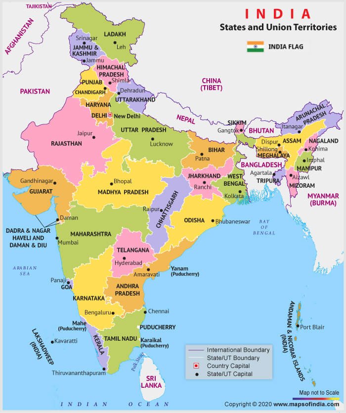
Article 1 of the constitution describes India, i.e. Bharat as a ‘ Union of States ‘. At present we have 28 States and 8 Union Territories (UTs). PARLIAMENT can divide a state, merge two states, change the name of any state, increase or decrease the area of any state etc. For example, Chhattisgarh was carved out of Madhya Pradesh. Madras was renamed as Tamil nadu etc.
Constitutional Provisions and Philosophical Basis
1 to 4, Part I – Deals with The Union and its territory
- Schedule – 1 – Names of the States and their territorial jurisdiction.
- 1 reads – India, that is, Bharat as a ‘Union of States’ rather than a ‘Federation of States’.
- This provision deals with two things: –
-
- Name of the country – India that is Bharat
- Type of polity – Union of States
- “India” and “Bharat” these two names in 1 is compromise between two divergent opinions. Some members suggested the “Bharat”, while other advocated the modern name “India”. Pertaining to this, Constituent Assembly had to adopt a mix of both (“India, that is, Bharat”)
- The phrase “Union of States” has been preferred to “Federation of States” for two reasons:
-
- The Indian Federation is not the result of an agreement among the states like the American Federation
- The states have no right to secede from the federation.
- The federation is a Union because it is indestructible. The country is an integral whole and divided into different states only for the convenience of administration.
- According to 1, the territory of India can be classified into three categories:
-
- Territories of the states
- Union territories
- Territories that may be acquired by the Government of India at any time.
- ‘Territory of India’ – Wider expression as it includes not only the states but also union territories and territories that may be acquired by the Government of India at any future time.
- States à The states are the members of the federal system and share distribution of powers with the Centre.
- Union Territories – Directly administered by the Central government.
- Acquired Territories – Directly administered by the Central government. Being a sovereign state, India can acquire foreign territories according to the modes recognised by international law – Cession, Occupation, Conquest or Subjugation.
- ‘Union of India’ – Narrower expression as it includes only states.
- Present status (as of 2020) – There are 28 states and 9 union territories.
- Fifth and Sixth Schedules contain separate provisions with respect to the administration of scheduled areas and tribal areas within the states.
- 2 – Relates to the admission or establishment of new states that are not part of the Union of India. Empowers the PARLIAMENT to ‘admit into the Union of India, or establish, new states on such terms and conditions as it thinks fit’.
- 2 accords two powers to the Parliament: –
-
- the power to admit into the Union of India new states (already in existence)
- the power to establish new states (not in existence before)
- 2 deals with external re-adjustment of the territories of the constituent states of the Union of India.
- 3 – Relates to the formation of or changes in the existing states of the Union of India.
- 3 deals with the internal re-adjustment interest of the territories of the constituent states of the Union of India
Authority of Parliament over Reorganization of State
- This power of parliament broadly deals with 3 of the constitution.
- 3 authorises the Parliament to: –
-
- Form a new state by separation of territory from any state or by uniting two or more states or parts of states or by uniting any territory to a part of any state
- Increase the area of any state
- Diminish the area of any state
- Alter the boundaries of any state
- Alter the name of any state.
NOTE
- In the case of state
-
- Bill contemplating the above changes can be introduced in the Parliament only with the prior recommendation of the President.
- Before recommending the bill, the President has to refer the same to the state legislature concerned for expressing its views within a specified period.
- The President (or Parliament) is not bound by the views of the state legislature and may either accept or reject them, even if the views are received in time.
- In the case of UTs
-
- In case of a union territory, no reference need be made to the concerned legislature to ascertain its views and the Parliament can itself take any action as it deems fit.
-
-
- Constitution authorises the Parliament to form new states or alter the areas, boundaries or names of the existing states without consent of states. These provisions entail that territorial integrity of any state is not guaranteed by the Constitution.
- India – “An indestructible union of destructible states”.
- USA – “An indestructible union of indestructible states” (territorial integrity of the states guaranteed)
- American Federal Government cannot form new states or alter the borders of existing states without the consent of the states concerned.
-
| 100th Constitutional Amendment Act (2015) was enacted to give effect to the acquiring of certain territories by India and transfer of certain other territories to Bangladesh in pursuance of the agreement and its protocol entered into between the Governments of India and Bangladesh. |
| Art. 4 – Itself declares that laws made for admission or establishment of new states (under Art.2) and formation of new states and alteration of areas, boundaries or names of existing states (under Art. 3) are not to be considered as amendments of the Constitution under Art.368. This means that such laws can be passed by a simple majority and by the ordinary legislative process. |
- Cessation of an Indian territory to foreign country does not cover under Art.3 and it can be done only by amending constitution under Art. 368.
| 7 th Constitutional Amendment Act 1956 – Led to creation of Zonal councils in india to advise on matters of common interest. They statutory in origin. Total 5 zonal councils exist in India. However, North-Eastern zonal council is created by separate statute in 1971 (North Eastern Council Act, 1972). The chairman of the Zonal council is Union Home Minister and Chief Ministers of the States included in each zone act as Vice-Chairman of the Zonal Council for that zone by rotation, each holding office for a period of one year at a time. |
- Settlement of a boundary dispute between India and another country does not require a constitutional amendment (Under Art. 368). It can be done by executive action as it does not involve cession of Indian territory to a foreign country.
- Before 1956, the states were classified into four parts-
- Part A – 9 former governor’s provinces
- Part B – 9 former princely states
- Part C – former princely states + chief commissioners provinces
- Part D – Andaman and Nicobar
- By the States Re-organization Act (1956) and the 7th Constitutional Amendment Act (1956), the four-fold division of state were abolished.
Evolutionary history of States and UTS
INTEGRATION OF PRINCELY STATES (SARDAR VALLABHAI PATEL WAS MAIN FORCE BEHIND)
- India had comprised two categories of political units –
- The British provinces (under the direct rule of British government)
- The princely states (under the rule of native princes but subject to the paramountcy of the British Crown).
- The Indian Independence Act (1947) created two independent and separate dominions of India and Pakistan and gave three options to the princely states –
- Joining India
- Joining Pakistan
- Remaining independent.
- Of the 552 princely states situated within the geographical boundaries of India, 549 joined India and the remaining 3 (Hyderabad, Junagarh and Kashmir) refused to join India.
- In course of time, they were also integrated with India–
- Hyderabad by means of police action (Operation POLO)
- Junagarh by means of referendum
| UT of Delhi was redesignated as National Capital Territory (NCT) according to 69th Constitutional Amendment Act 1991. |
- Kashmir by the Instrument of Accession.
Dhar Commission and JVP Committee (1948)
- The integration of princely states with the rest of India has purely an ad hoc arrangement.
| Andhra State Act, 1953 – Formed the first linguistic state, known as the State of Andhra, by taking out the Telugu speaking areas from the State of Madras. Kurnool was the capital of Andhra State and the state high court was established at Guntur. |
- Government of India appointed the Linguistic Provinces Commission under the chairmanship ofK. Dhar in 1948 to examine the feasibility and evolution of an objective criteria.
- Committee recommended the reorganization of states on the basis of administrative convenience rather than linguistic factor.
- Disappointment with Dhar committee led to the appointment of another Linguistic Provinces Committee in 1948 consist of Jawaharlal Nehru, Vallabhai Patel and Pattabhi Sitaramayya, itself to examine the whole question afresh.
- JVP committee formally rejected language as the basis for reorganisation of states.
Fazl Ali Commission (1953)
- The creation of Andhra state in 1953 intensified the demand from other regions for creation of states on linguistic basis.
- This forced the Government to appoint a three- member States Reorganisation Commission in 1953, under the of to re-examine the whole question.
- Members – Fazl Ali (chairmanship), M. Panikkar and H.N. Kunzru.
- Committee broadly accepted language as the basis of reorganisation of states.
- At same time, it rejected the theory of “one language-one state”.
- Its view was that the unity of India should be regarded as the primary consideration in any redrawing of the country’s political units.
- It identified four major factors that can be taken into account –
- Preservation and strengthening of the unity and security of the country.
- Linguistic and cultural homogeneity.
- Financial, economic and administrative considerations.
- Planning and promotion of the welfare of the people in each state as well as of the nation as a whole.
New States and Union Territories Post – 1956
- Maharashtra and Gujarat – In 1960, the bilingual state of Bombay was divided into two separate states – Maharashtra (Marathi speaking people) and Gujarat (Gujarati speaking people).
- Dadra and Nagar Haveli – The Portuguese ruled this territory until its liberation in 1954. It was converted into a union territory of India by the 10th Constitutional Amendment Act, 1961.
- Goa, Daman and Diu – India acquired these three territories from the Portuguese by means of a police action in 1961. They were constituted as a UTs by the 12th Constitutional Amendment Act, 1962. Goa was conferred statehood in 1987. Consequently, Daman and Diu was made a separate union territory.
- Puducherry – The territory of Puducherry comprises the former French establishments in India known as Puducherry, Karaikal, Mahe and Yanam. It was administered as an ‘acquired territory’, till 1962 when it was made a UT by the 14th Constitutional Amendment Act.
- Nagaland – In 1963, the State of Nagaland was formed by taking the Naga Hills and Tuensang area out of the state of Assam.
- Haryana, Chandigarh – On the recommendation of the Shah Commission (1966), in 1966, the State of Punjab was bifurcate to create Haryana, and the UT of Chandigarh.
- Himachal Pradesh – In 1971, the UT of Himachal Pradesh was elevated to the status of a state of the Indian Union.
- Manipur, Tripura and Meghalaya – In 1972, the two UTs of Manipur and Tripura and the sub-state of Meghalaya got statehood and the two UTs of Mizoram and Arunachal Pradesh (NEFA) came into being.
- Sikkim: Till 1947, Sikkim was an; Indian princely state ruled by Chogyal. In 1947, after the lapse of British paramountcy, Sikkim became a ‘protectorate’ of India.Indian Government assumed responsibility for the defence, external affairs and communications of Sikkim.The 35th Constitutional Amendment Act (1974) was enacted by the parliament. This amendment introduced a new class of statehood under the constitution by conferring on Sikkim the status of an ‘associate state’ of the Indian Union.For this purpose, a new Art. 2-A and a new schedule (10th Schedule) were inserted in the Constitution.The 36th Constitutional Amendment Act (1975) was enacted to make Sikkim a full-fledged state of the Indian Union (the 22nd state).This amendment amended the First and the Fourth Schedules to the Constitution and added a new Art. 371-F to provide for certain special provisions with respect to the administration of Sikkim.It also repealed 2-A and the 10th Schedule.
- Mizoram, Arunachal Pradesh and Goa – In 1987, three new States of Mizoram (Mizoram Peace Accord 1985), Arunachal Pradesh and Goa came into being states of the Indian Union.
- Chhattisgarh, Uttarakhand and Jharkhand – In 2000, three more new States of Chhattisgarh, Uttarakhand and Jharkhand were created out of the territories of Madhya Pradesh, Uttar Pradesh and Bihar, respectively.
- Telangana – In 2014, the new state of Telangana came into existence as the 29th state of the Indian Union. It was carved out of the territories of Andhra Pradesh.
- Jammu & Kashmir and Ladakh:
-
- Till 2019, the erstwhile State of Jammu and Kashmir had its own constitution and thus enjoyed a special status by virtue of 370 of the Constitution of India.
- In 2019, this special status was abolished by a presidential order known as “The Constitution (Application to Jammu and Kashmir) Order, 2019”.
- Jammu and Kashmir Reorganisation Act, 2019, bifurcated the erstwhile State of Jammu and Kashmir into two separate UTs –
- UT of Jammu & Kashmir – Comprises all the districts of the erstwhile State of Jammu and Kashmir except Kargil and Leh districts
- UT of Ladakh – Kargil and Leh districts
Thus, the number of states and union territories increased from 14 and 6 in 1956 to 28 and 9 in 2019, respectively.
Former UTS Transformed into Present States in Indian Union
- Goa, Diu-Daman, Puducherry, Himachal Pradesh, Manipur, Tripura, Mizoram, Arunachal Pradesh.
Evaluating Linguistic Reorganization of States
- Gandhi and Nehru initially were in favour of linguistic reorganization. After Nagpur session, Pradesh Congress Committee (PCC) were setup in 1920.
- After witnessing horrors of partition, Nehru had a change of heart and from an outright supporter he became staunchest critique.
- Late 1940s witnessed a resurgence for linguistic states. E.g. Sanyukta Karnataka, Maha – Gujarat and Punjab.
- Most vigorous moment was in Telgu speaking areas of Madras speaking. This movement was initially spurred by led by Swami Sitarman and later by Pottu Sriramalu. This was resulted in formation of Andhra Pradesh in 1953.
Merits
- Secular mode – Linguistic basis is more secular mode than caste of religious base.
- Better learning outcome – Linguistic provinces can provide education in mother tongue.
- Unity in diversity – Promotion and development of regional language and culture.
- Masses can participate in democratic process if language of administration is of their own.
- Efficient Administration – Multilingual state would be very difficult to administer efficiently and effectively.
Demerits
- It would likely spur further such demands and given no. of languages in country.
- Regionalism – It would slow down the process of emergence of national identity and composite culture.
- Sub-nationalism – Encouraging subnational feeling which may result into Balkanization of country.
- Sub-national identity often become rallying point and a platform for voicing secular demands. E.g. Marathi vs Bihari issue.
- Small states are not always economically and financially viable. E.g. Jharkhand.
GOI’S Response to the Demands for States
- Special developmental assistance and package
- Creation of an Autonomous Councils e.g. Darjeeling Gorkha Council
- Inclusion of language in eight schedule of constitution – E.g. Konkani, Bodo etc.
- Setting up Developmental Boards – E.g. Vidarbha and Saurashtra.
- Special category status.
Critical Analysis of Demand for Small State
Reasons for Demand
Culture and Ethnicity – For instance, Gorkhaland out of West Bengal, Nagalim demand in North East, Bodoland in Assam.
- Better governance – E.g. proposal to split Uttar Pradesh into smaller states.
- Political reasons – E.g. some groups dominated western UP region demanding Harit Pradesh.
- Imposition of local language and culture by the state government – E.g. in West Bengal
- Economic backwardness – e.g. Telangana and Vidarbha.
Merits
- Administrative convenience – more effective and efficient.
- Smaller state is more likely to be homogenous in terms of its developmental aspirations.
- It facilitates the people participation as administration become more closer to peoples.
- Viability of small states also resonates in economic growth experience of several small state.
- Democratic Decentralisation
- Resolve the problem of identity crisis among the ethnic groups and enable them to develop their own language and culture.
Demerits
- Question of defining “small state” and objective criteria for same.
- Complication of matter w.r.t allocation of finances, center – state relations.
- Would go against spirit of Vallabhai Patel – against consolidation drive.
- No guarantee of enhancing of Human development indicators (HDI)
- Would lead to more dependence on center for finances attributed to low tax base.
- Issue of economic viability – North East states are more dependent on center.
- Duplication and overlapping of administrative setup – courts, Human resources.
Conclusion
- If its assumed that small states jurisdiction are developmentally more efficient then such arrangement already exist in the form of local bodies and in the form of blocks. Effective, efficient utilization of these institutions and capacity building is way forward.
Need for Second State Reorganization Commission
- It shall lay down sound and objective criteria for reorganization.
- Reorganization is an evolving process instead of one stop solution.
- Population in several states have become exponentially large.
- 30 years on LPG reform have altered the demographic and socio-economic realities leading to regional sentiments of neglect.
- To explore the ways to match the contemporary developmental aspirations and economic realities.
- To ensure equitable and inclusive social, economic, environmental growth.
Illustrative List of Demand for Independent States
- Uttar Pradesh – Bundelkhand
- Maharashtra – Vidarbha
- Bihar – Mithilanchal
- West Bengal – Gorkhaland
- Assam – Bodoland
- Delhi as state
- Puducherry
Delhi as State – Critical Evaluation
In favour
- 69th Amendment 1991 created the Legislative Assembly of Delhi. Today, there are nearly two crore people in Delhi. It will be unfair to have restricted power to such popular mandate.
- It would also provide equal right of people for representation and self- governance.
- UN report projects that Delhi urban agglomeration will make it the most populous city in the world by 2028.
- An elected government representing a massive population need to have a say in law and order and land management.
- Statehood would resolve the of issue of coordination and frequent tussle between CENTRAL GOVERNMENT and Delhi government.
In Against
- Demand for full statehood has not been a national compulsion, but a call fuelled by Delhi’s local political interest and ambitions.
- Delhi is the national capital and must necessarily be viewed from the prism of the interests of the entire country.
- Delhi harbours institutions of national importance such as the president’s estate, the Parliament and foreign embassies. Special security cover and close coordination is essential for protection of these infrastructures.
- These institutions are the sole responsibility of the Union Government and not of any one particular state legislative assembly.
- India’s national capital belongs to every citizen of the country and not just those who reside in the city.
- Administrative burden over Delhi government would be enormous such as civic amenities, law and order, finances etc.
Way Forward
- Overlapping jurisdictions in a national capital is inbuilt and constitutional entities have to manage this reality.
- Provide greater autonomy and reasonably robust fairer power-sharing arrangements among different constituents.
- Governance restructuring would need to be done in a manner that accountability in relation to specific functions falls squarely on a single organisation/individual.
- Delhi should demand the urgent revision of the existing constitutional provisions (i.e. 69th Amendment, Article 239) and Rules of Business.
Aksai Chin and Associated Issues
Historical Underpinning
- India and China share a 3,488 km long boundary. Unfortunately, the entire boundary is disputed.
- Four states viz., Himachal Pradesh, Uttarakhand, Sikkim and Arunachal Pradesh and a Union Territories of Ladakh (erstwhile state of Jammu & Kashmir) share a border with China.
- India and China had never shared a common boundary till China “liberated” or occupied Tibet in 1950.
- It was then that the hitherto India Tibet boundary was transformed into an India-China boundary.
- Since 1954, China started claiming large tracts of territory along the entire border such as Aksai Chin in Jammu and Kashmir, some areas in Uttarakhand and the entire Arunachal Pradesh.
- This episode was followed by intermittent clashes along the border, which finally culminated in the border war of 1962.
- The boundary, which came into existence after the war, came to be known as Line of Actual Control (LAC). It is a military held line.
- The Sino-Indian border is generally divided into three sectors namely: –
- Western sector
- Middle sector
- Eastern sector
- There have been no fires shot along Aksai chin border over last 40 years.
- There are three stages of negotiation:
- Agreeing to guiding principles to be followed – this is done
- Recognizing Boundary and area – evolving consensus – this is the toughest one and process is struck here
- Demarcation of boundaries
Western Sector
- In the western sector, India shares about 2152 km long border with China.
- It is between Union Territory of Ladakh (erstwhile state of Jammu and Kashmir) and Xinjiang Province of China.
- In this sector, there is a territorial dispute over Aksai Chin.India claims it as part of erstwhile Kashmir, while China claims it is part of Xinjiang.
- The dispute over Aksai Chin can be traced back to the failure of the British Empire to clearly demarcate a legal border between China and its Indian colony.
- During the time of British rule in India, two borders between India and China were proposed- Johnson’s Line and McDonald Line.
- The Johnson’s line (proposed in 1865) shows Aksai Chin in erstwhile Jammu and Kashmir(now Ladakh)e. under India’s control whereas McDonald Line (proposed in 1893) places it under China’s control.
- India considers Johnson Line as a correct, rightful national border with China, while on the other hand, China considers the McDonald Line as the correct border with India.
- At present, Line of Actual Control (LAC) is the line separating Indian areas of Ladakh from Aksai Chin. It is concurrent with the Chinese Aksai Chin claim line.
Middle Sector
- In this sector, India shares about 625 km long boundary with China which runs along the watershed from Ladakh to Nepal.
- Himachal Pradesh and Uttarakhand touch this border with Tibet (China) in this sector. Both sides do not have much disagreement over the border in this area.
Eastern Sector
- In this sector, India shares a 1,140 km long boundary with China.
- It runs from the eastern limit of Bhutan to a point near the Talu-Pass at the trijunction of Tibet, India and Myanmar.
- This boundary line is called McMahon Line.
- China considers the McMahon Line illegaland unacceptable claiming that Tibetan representatives who had signed the 1914 Convention held in Shimla which delineated the McMahon line on the map were not having rights to do so.
Pakistan Occupied Kashmir (PoK) issue
External Affairs Minister S. Jaishankar said (Sept 2019) that “we expect one day we will have physical jurisdiction” over Pakistan Occupied Kashmir (PoK).
Supporting Regulation
- A resolution unanimously adopted by Parliament on February 22, 1994 affirmed that “the UT of Jammu & Kashmir has been, is and shall be an integral part of India.
- It demanded that Pakistan must vacate the areas of the Indian State of Jammu and Kashmir, which they have occupied through aggression.
- PoK and GB are both part of the UT of Jammu and Kashmir, which is an integral part of India by virtue of its accession to India in 1947.
THE PoK
- PoK is an area of 13,297 sq. km, which was under the control of the Pakistani forces when the ceasefire line came into effect on January 1, 1949.
- That was after a 14-month period of hostilities between India and Pakistan, which began with an invasion of Kashmir by Pashtun tribesmen, and later its Army, to seize Kashmir.
- In 1963, through an agreement, Pakistan ceded to China over 5,000 sq. km of J&K land under its control, in the Shaksgam area, in northern Kashmir, beyond the Karakoram.
Demography of PoK
- PoK has a population of over 40 lakh (4 Million), according to a census carried out in 2017.
- It is divided into 10 districts: Neelum, Muzaffarabad, Hattian Bala, Bagh, and Haveli bordering areas in Kashmir, and Rawlakot, Kotli, Mirpur, and Bhimber bordering areas in Jammu.
- The capital of PoK is Muzaffarabad, a town located in the valley of the Jhelum river and its tributary Neelum (which Indians call Kishanganga) to the west and slightly north of Srinagar.
GILGIT – BALISTAN Issue
Historical Background
- This is a picturesque, hilly region to the north of PoK and east of the Pakistani province of Khyber Pakhtunkhwa.
- The British sold it, along with the rest of Jammu and Kashmir, to the Dogra ruler of Jammu, Gulab Singh, after defeating the Sikh army in 1846.
- However they retained controlled over the area through a lease extracted from the Maharaja. This lease was last renewed in 1935.
- In 1947, a British army officer of the rank of Colonel imprisoned Maharaja Hari Singh’s governor in the region, and handed over the area for accession to Pakistan.
Administrative Status in GILGIT – BALISTAN
- Gilgit Baltistan (GB) is spread over 72,871 Sq. km, and is five-and-a-half times the size of PoK. But it is sparsely populated, with just under 20 lakh (2Million)
- GB is divided into three administrative divisions and 10 districts.
- Though both PoK and GB are ruled directly from Islamabad, neither is officially listed as the territory of Pakistan.
- Pak has just four provinces: Punjab, Khyber-Pakhtunkhwa (which now includes the Federally Administered Tribal areas or FATA), Balochistan, and Sindh.
- PoK and GB are both “autonomous territories”.
- Pakistan has kept this fiction going, as incorporating these areas into its map would damage its international position in the UN and elsewhere that the entire Jammu and Kashmir is “disputed”.
|
Union Territory |
Capital |
| Andaman and Nicobar Islands | Port Blair |
| Chandigarh | Chandigarh |
| Dadra and Nagar Haveli and Daman and Diu | Daman |
| Delhi | New Delhi |
| Jammu and Kashmir | Srinagar (Summer), Jammu (Winter) |
| Ladakh | Leh (summer), Kargil (winter) |
| Lakshadweep | Kavaratti |
| Puducherry | Puducherry |